989m - 13.7 km (Embrun)
[FR-05-1791]
|
Height | Climbing height - length |
| 1791m | 916m - 17.6 km (St-Clément-sur-Durance) 989m - 13.7 km (Embrun) |
|
| Difficulty | Beauty | |
| 3 (5) | 3 (5) | |
| How to get there | This pass is only asphalted from the northwest, while the other side start from the same place, but culd also (and more logical) start in Embrun (Le Pont Neuf) (802m), but this side is gravel in the upper area (look at geoportail.fr for better understanding of the road options). The very nice and small road that starts in St-Clément-sur-Durance (875m) climbs very gently at first, but the climb later becomes steeper (when turning off the D994d road) and then very steep in some places with up to 17% (according to the Michelin map). There are some drainage gullies on the road higher up and you should take care going down this road as it can be quite dangerous. The higher part is mostly in the woods and not so nice. | |
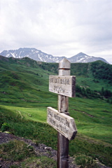
| Other comments | I came down to this pass from Col de Valbelle (2381m) on a bad gravel road from Risoul. This road is not recommended for road bicyclists between Col de Valbelle and Col de la Coche, where there can be water to ford (I had to take off the shoes) and stretches to walk. It looks like there should be a nice little road to a viewing point across the Durance valley just a little before the pass height on the tarmacced road, which I did not think of visiting when passing by. There is probably no water along the climb. (Photo taken at Col de Chérine (2270m) (near the Valbelle pass) in the direction of this pass.) [FR-05-1791] |
|
| Map |
||