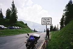
Sign 1778m
1298m - 18.2 km (Ollon)
1359m - 28.2 km (Aigle)
614m - 8.3 km (Les Diablerets)
426m - 6.9 km (Chemin de Bretaye)
[CH-VD-1778/CH-VD-1731, BIG 545]
|
Height | Climbing height - length |
| 1776m Sign 1778m |
1344m - 22.8 km (Bex) 1298m - 18.2 km (Ollon) 1359m - 28.2 km (Aigle) 614m - 8.3 km (Les Diablerets) 426m - 6.9 km (Chemin de Bretaye) |
|
| Difficulty | Beauty | |
| 4 (5) | 3-4 (5) | |
| How to get there | The road from the Bex (432m) via Gryon (1114m) and Villars-s-Ollon (1253m) is quite nice with mostly open views of mountains all around. It is also quite steep in places, but the road is almost flat between Gryon and Villars. On this latter stretch a railway with trains is occupying half of the road and you better watch out here! The road from Ollon (478m) via Villars is also steep, but wide and good. From Villars the climb continues quite steep to the pass. The approach from Les Diablerets (1162m) in the north is not as hard because it is not so long, but if you climb all the way from down in Aigle (417m) it will be a long and hard climb too. | |
| Other comments | It is more beautiful on the southern side (at least it was not so very nice from Les Diablerets and up). There is a restaurant at the pass height. This is a pass that connects with the Col du Pillon (1546m) via Les Diablerets. The road over Col de Bretaye (1805m) is much more fun and harder, with better views (and ca. 1.8 km gravel). On a small asphalt road down from the main road on the west side you reach after 140 metres the old Col de la Croix/Col inférieur de la Croix (1733m). [CH-VD-1778/CH-VD-1731, BIG 545] |
|
| Map |
||