1468m - 21.26 km - 6.9% (Stazzona)
1477m - 21.22 km - 7.0% (Svandana)
1492m - 22.43 km - 6.7% (Tresenda)
727m - 13.20 km - 5.5% (Aprica)
966m - 10.97 km - 8.8% (Megno-Doverio)
1182m - 17.16 km - 6.9% (Edolo)
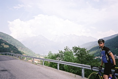
Climbing from just east of Passo di Aprica (1174m) to this little known pass is the most obvious approach, but there are several options. The most interesting starting point for climbing this pass is from the south at Lombro (901m) or lower down at Edolo (685m) on a road not often shown on maps. The Megno/Doverio road is quite steep with some stretches around 20% (signs suggests 25%, which is not quite true) and on this side it is a highly irregular climb. This side is just a little less hard than the famous nearby Passo della Foppa/Pas de la Foppa (Passo del Mortirolo) (1855m).
From the north you can start from Stazzona (399m), Svandana (390m) and Tresenda (375m) west of Tirano and climb via Passo di Santa Cristina (1436m) or start in Tirano (447m) and climb via Cologna to Trivigno. These approaches all have steep stretches, but the Cologna climb is the hardest (unevenly steep). The climbs from Stazzona, Svandana and Tresenda uses parts of the main road to Passo di Aprica, but then one turn off onto the Passo di Santa Cristina road. This is the last and second proper road going off the Passo di Aprica road after the first real hairpin bend on the Aprica road (the first more obscure road is the S. Rocco road, which it says on a stone there). (The S. Rocco road is asphalted, but I do not believe the road taking off from S. Rocco is paved and perhaps not good enough for a road bike.)