 Col de St-Pantaléon/Colle di St. Pantaleon Col de St-Pantaléon/Colle di St. Pantaleon |
 |
Height |
Climbing height - length |
| 1655m (road height 1666m) |
1177m - 16 km (Chambave via St-Denis)
1177m - 16.8 km (Chambave via Verrayes)
1289m - 19 km (Chambave via Verrayes/Grand-Villa)
1154m - 17.4 km (Ronchettes)
1266m - 19.6 km (Ronchettes via Grand-Villa)
1135m - 16.7 km or 17km or 1137m - 16.8 km (Champagne)
1247m - 18.9 km or 19.2km or 1137m - 19 km (Champagne via Grand-Villa)
1128m - 16.2 km (Châtillon via Cerian-Villettaz)
1128m - 17.1 km (Châtillon via Antey-Saint-André)
640m - 9.4 km (Antey-Saint-André) |
| Difficulty |
Beauty |
| 4 (5) |
4 (5) |
| How to get there |
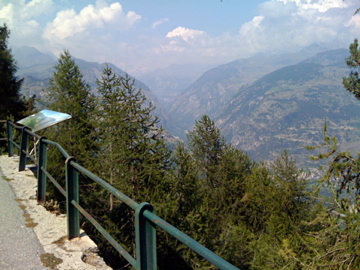
There are many alternative roads up here and I am not even including my own alternative from Ronchettes via Col des Bornes/Col de Bornel (1781m). The most well-known and classical climb up here is the one starting in Chambave (478m) that goes via St-Denis. This climb is the most consistently steep climb up, but on a good and wide road. I included an alternative road choice up from Châtillon (538m) via Torgnon (1527m) that should be similar in difficulty. I could recommend the road via Grand-Villa as it is very scenic and on a good road too with little traffic, but watch out for the water canons – they look serious enough to make you worried! See the map for most of the alternative roads. |
| Other comments |
From the top of the road you can in fine weather get a good glimpse of Matterhorn! The roads up the mountainsides in Aosta are nearly always very nice. Verrayes (1019m) at least have a bar and probably a grocery too. Torgnon is a touristy place. This could be climbed as part of the climb up to Breuil-Cervinia (+2000m). The gravel track/path between Col des Bornes/Col de Bornel is almost entirely usable with a road bike (the road from Champlong to Col des Bornes is a bit hard with a road bike, but not so bad).
[IT-AO-1655] |
Map
|
|