1312m - 27.1 km (1091m - 23.2 km) (Les Rouines)
This is the sister mountain to Mont Ventoux (1897m). It is not many who climbs the Mont Ventoux that would even have heard about this mountain, even if closer to the main Alps. This climb is also easier than the Mont Ventoux or more comparable to the Mont Ventoux climb from Sault (which is the easier of the three classic ones). I found the gradual, but relentless climb from St-Étienne-les-Orgues (688m) quite demanding, but it was after climbing Mont Ventoux.
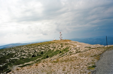
The highest pass is lower than the high point of the road (1748m) and below the mountain top (1820m), just like with Col des Tempêtes on Mont Ventoux. The climb from the north is very much through the woods, but it is more consistently steep on a narrow road up the last long part. It is worth getting up to the summit even though the access road at first looks really bad (a short stretch of gravel at least in 2008) from where you can see Mont Ventoux clearly in the west in good weather.
[FR-04-1597/FR-04-1704]