1490m - 20.4 km (Isola)
1847m - 34.4 km (St. Sauveur-s-Tinée)
1869m - 38.6 km (Col St-Martin road)
1921m - 40 km (Ilonse road)
2050m - 48.4 km (Pont de Clans)
2118m - 53.5 km (Pont de la Lune)
2164m - 58 km (Tinée valley)
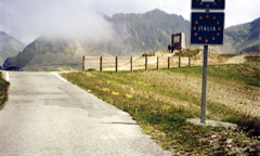
A tightly hairpinned road starts in the woods near the village of Vinadio (880m) in Italy on the north side. This road is often steep, but never above ca. 13%. On the south side the climb starts in Isola (861m) if coming down from the Col de la Bonette (Cime de la Bonette) (2715m (2804m)) or Col de la Moutière (2444m) or in St. Sauveur-s-Tinée (504m), if you come via Col de la Couillole/Col de Cogliola (1677m). There are some steep sections on this side too, but it seems like the easier side.
If you come via Col de Saint-Martin (1502m), you start at the height of 482m down the Tinée valley. If you happen to come down the nice road over Col de la Sinne/Sine/Sinna (1438m), you start at 430m. You could start at Pont de Clans (301m) if coming into the valley via Tournefort. You could have visited Col d’Andrion (1684m) or travelled over the road passing by the famous Madone d’Utelle (dangerous road down to La Tour). If so, then you start at Pont de la Lune (233m). You could finally also have started at the start of the Tinée valley (187m).
[FR-06-2350a, BIG 309]