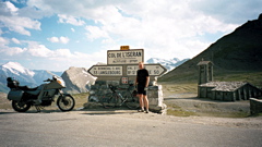
Sign 2770m
2041m - 46.5 km (Séez D119)
1959m - 44.5 km (Séez)
1751m - 35.6 km (Ste-Foy-Tarentaise)
2232m - 72.5 km (St-Michel-de-Maurienne)
1428m - 29.5 km (Lanslevillard)
956m - 12.6 km (Bonneval-sur-Arc)
On the long north side you can find water in La Thuile. The views are stunningly beautiful on the south side above Bonneval-s-Arc (1808m), but apart from that it is not the nicest of passes. I thought it was nicer above Val d’Isère (bad road through the village) when going over from the south side in 2006 (than in 2002). There are very long and wide serpentines above Val d’Isère (1840m) on the north side that are impressive. There is a long tunel on the north side before a road that takes off to Tignes, but this tunnel is well lit. There are also some unlit tunnels (2006). On the north side you could take the alternative road via Villaroger (840m – 1100m – 1006m).
As this is a very high pass, you should expect low temperatures at the pass height even in Summer (I had snow and zero degrees Celcius in July 2014). Bourg-St. Maurice is a rather disappointing village and does not seem to have a grocery shop (someone said he found one, but I still have not seen one (even asking locals) and going through the village 4 times, but they do have a McDonalds … ). The old Hostellerie du Petit Saint Bernard was nice (think it is closed down now).
On the south side you pass by another pass (at least if taking the local road above Lanslevillard), namely Le Collet/Col de la Madeleine (1753m). The climb up via Aussois to Plan d’Aval (2037m) is nice and somewhat steep, but it is only really nice if you continue on the gravel and walk the last hundred metres up to the second dam – Barrage du Plan d’Amont (2080m).
On the north side you can also visit Val Claret/Tignes (2140m) (ski resort) and the nice Le Saut (2280m) on the opposite side of the main road.
See also: Col du Petit Mont Cenis/Colle Piccolo Moncenisio (2183m); Col du Mont Cenis/Colle del Moncenisio (2083m); Plan du Lac (Bellecombe) (2373m) and Porte de l’Orgère (Le Col) (1949m (1628m)).
[FR-73-2764, BIG 286]