1072m - 17.9 km (1610m - 25.7 km - Millefonts) (Ilonse road)
1201m - 26.3 km (1739m - 34.1 km - Millefonts) (Pont de Clans)
1269m - 31.5 km (1807m - 39.2 km - Millefonts) (Pont de la Lune)
1315m - 35.9 km (1853m - 43.7 km - Millefonts) (Tinée valley)
1002m - 20.6 km (1661m - 31.8 km - Millefonts) (La Bollène-Vésubie)
1064m - 23.2 km (1723m - 34.4 km - Millefonts) (Lantosque (D73))
1204m - 31.3 km (1863m - 42.5 km - Millefonts) (St-Jean la Rivière)
1359m - 41.6 km (2018m - 52.8 km - Millefonts) (Plan du Var/Pont Durandy)
From the west you start in the Tinée valley at the turn-off for Colmiane and Valdeblore if you are coming down from Col de la Couillole/Col de Cogliola (1677m), Col de la Lombarde/Colle della Lombarda (2350m) or Col de la Bonette (Cime de la Bonette) (2715m (2804m)). This climb is the most consistently steep one to the pass.
Otherwise you would start the climb lower down: If you happen to come down the nice road over Col de la Sinne/Sine/Sinna (1438m), you start at 430m. You could start at Pont de Clans (301m) if coming into the valley via Tournefort. You could have visited Col d’Andrion (1684m) or travelled over the road passing by the famous Madone d’Utelle (dangerous road down to La Tour). If so, then you start at Pont de la Lune (233m). You could finally also have started at the start of the Tinée valley (187m).
The climb on the west side starts in La Bollène-Vésubie (500m) if you come down the nice road from Col de Turini (1606m). Further down south of Lantosque (D73) (438m) would be the start of the climb if coming down from Col de la Porte (1057m). If you come down the good side of the Madone d’Utelle, you will start in St-Jean la Rivière (298m). If you come from Levens via the nice Duranus road on the other side of the valley you come down a bit earlier at roughly the same height and a short distance from the road to Utelle. Finally you could have come straight up the main road from Plan du Var/Pont Durandy (143m).
There are some road variations up the Vésubie valley and you could for example visit Roquebillière on the way up. I would say the climb up the Vésubie valley is nicer than the western climb.
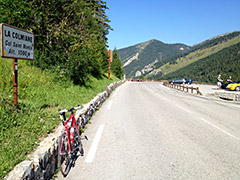
A good idea in fine weather is to continue higher up to Vallon de Millefonts (2040m) (or toward that valley as it is). This road starts 1.7 km down on the west side of the pass at 1382m (658m/9.5 km to climb), with a sign saying just Millefonts.
If you continue up the Vésubie valley to Le Boréon and up the Vallon de Salèse to Col de Salèse (2031m) where continuous asphalt runs out where the Mercantour park starts at a parking place (1681m). I have still not tried this road and have heard it should be possible with a road bike and that some part of the gravel section (4.3 km) should have some pavement.
From St-Martin-Vésubie (967m) you could also go in the other direction up to La Madone de Fenestre/des Fenestres (1905m), which is an interesting road (11.4 km/938m) (also not yet explored by me).
[FR-06-1500, BIG 325]