Sign 2259m, Sustenpass (tunnel) 2224m
1808m - 42.6 km (Altdorf)
1344m - 18.3 km (Wassen)
[CH-BE-2264a, BIG 567]
|
Height | Climbing height - length |
| 2260m Sign 2259m, Sustenpass (tunnel) 2224m |
1634m - 27.8 km (Innertkirchen) 1808m - 42.6 km (Altdorf) 1344m - 18.3 km (Wassen) |
|
| Difficulty | Beauty | |
| 4 (5) | 3-4 (5) | |
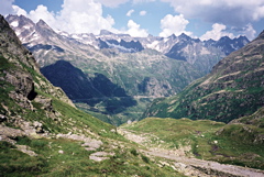
| How to get there | From the west the climb starts above Meiringen in Innertkirchen (626m). If arriving from the north or from Klausenpass, the climb starts already at Bürglen/Altdorf (488m) after a descent to 452m. If you come from the south, the Andermatt area, you start the climb when you turn off the road down the valley at Wassen (916m). (This supposes you go through the tunnel pass and up the other side of the pass as you cannot cycle with a road bike (anyway) up the east side of this pass.) It is not a very steep pass, apart from the short climb up from the tunnel, but it is a very long one! | |
| Other comments | It is nice with the tunnels and bridges on the east side above Wassen (photo). The hairpinned road near the top on the west side is also very nice! I did not see any place for water above Wassen on the east side. There is a bar just below the top serpentines on the west side and two at the top itself (one of which is at the top of Sustenpasshöhe). Accomodation could be found in Meiringen, Innertkirchen, and Guttanen on the west side and in Wassen on the east side. The new Sustenpass road opened in 1947. See also Sustenpass (tunnel) (2224m). (The photo shows the east side of this pass.) [CH-BE-2264a, BIG 567] |
|
| Map |
||