Sign 2236m
920m - 9.8 km (Selva di Cadore); 1084m - 15.8 km (Rucava/Reciavé)
1237m - 15.7 km (Caprile); 1391m - 21 km (Caprile via Colle S. Lucia)
[IT-BL-2236, BIG 716]
|
Height | Climbing height |
| 2232m Sign 2236m |
729m - 10.3 km (Pocòl); 1070m - 15.9 km (Cortina d’Ampezzo) 920m - 9.8 km (Selva di Cadore); 1084m - 15.8 km (Rucava/Reciavé) 1237m - 15.7 km (Caprile); 1391m - 21 km (Caprile via Colle S. Lucia) |
|
| Difficulty | Beauty | |
| 4 (5) | 4 (5) | |
| How to get there | From the east one could start in the old olympic ski resort town of Cortina d’Ampezzo (1199m) and it will be an ardous climb from there, with some real steepness at the last section. One takes left at Pocòl (1503m). If coming down from Passo di Falzarego/Fouzargo/Jou de Fauzare (2105m) toward Cortina, one starts the climb from the east at Pocòl. From the west the still steeper climb starts at Selva di Cadore (1312m) or from Caprile (1002m). The direct road from Caprile (995m) was closed for traffic in 2006, so one had to go via Colle S. Lucia (1473m) with extra height metres. If coming from Passo Pordoi, Passo Campolongo or Passo Falzarego, the climb starts with the small climb over Colle S. Lucia from Rucava/Reciavé (1309m). The climb from Selva di Cadore is very steep with up to 14% here and there. | |
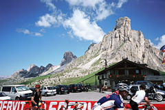
| Other comments | This is another of the classic Dolomites passes and one of the steeper ones. Good surface and beautiful scenery at the top, but not so much nice views lower down. There is a nice old hotel at Pocòl (the one you go around if coming from/to Passo Falzarègo), but I guess you can find cheaper accomodation at other villages (though likely not in Cortina). There is a bar at the top of the pass. Fill up water before starting out on this pass. There is water near the top on the west side. The ladin badiot name for the pass is Ju de Giau. [IT-BL-2236, BIG 716] |
|
| Map |
||