Signs 2212m, 2220m
1215m - 28.1 km (Guillestre)
1356m - 31.9 km (Guillestre N94)
[FR-05-2220a]
|
Height | Climbing height |
| 2212m Signs 2212m, 2220m |
859m - 11.5 km (Château-Queyras) 1215m - 28.1 km (Guillestre) 1356m - 31.9 km (Guillestre N94) |
|
| Difficulty | Beauty | |
| 3 (5) | 5 (5) | |
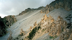
| How to get there | This pass is on the south side of the Col d’Izoard road and is located on the parking place at the famous Casse Deserte. The climb to here from Château-Queyras (1353m) is the main difficulty on the Col d’Izoard pass climb. It is quite steep after Arvieux. | |
| Other comments | There are two signs announcing this pass at the parking place, but its authenticity as a true pass has been debated. On this map excerpt at centcols.org website you could see a path leading off (to another valley) from the point of this pass, so it is apparently correct. For cyclists this is just a place on the way to or from Col d’Izoard (2361m) (see that pass for more information). [FR-05-2220a] |
|
| Map |
||