1916m - 39.9 km (2005m - 40.7 km - Cime) (Isola)
2273m - 52 km (2362m - 53.9 km - Cime) (St. Sauveur-s-Tinée)
2295m - 58.1 km (2384m - 58.9 km - Cime) (Col St-Martin road)
2347m - 59.5 km (2436m - 60.3 km - Cime) (Ilonse road)
2476m - 67.9 km (2565m - 68.7 km - Cime) (Pont de Clans)
2544m - 73 km (2633m - 73.8 km - Cime) (Pont de la Lune)
2590m - 77.5 km (2679m - 78.3 km - Cime) (Tinée valley)
1496m - 22.1 km (1585m - 23.1 km - Cime) (Jausiers)
It is possible to almost entirely avoid any descent until the pass (and mountain) for all the way from Nice. One should of course continue up to the Cime de Bonette at 2804 metres – 0.87 km on the south side, that should be climbed if coming from the south, and 1.06 km down on the north side. This makes it a 2800 metres climb from Nice and the longest climb in the Alps. This is the highest asphalted road in the western Alps and only the Austrian Tiefenbach Gletscherstraße (2820m) goes a little higher.
From the Ubaye valley to the north one starts the climb in Jausiers (1219m). From there it is a rather regular and a moderately steep pass road to the top. On the south side it only starts to get a bit steep just before St. Sauveur-sur-Tinée (504m), but first after St. Etienne-de-Tinée (1144m) (53km) the climbing is relentless until the top (if you take the small road through the village you escape the extra 62m climb on the main road). From St. Etienne-de-Tinée the climb is somewhat similar to the north climb from Jausiers. However, unless you come back down from the climb up to Col de la Moutière (2444m) and start your climb from St. Dalmas-le-Selvage (1347m), you will have a much longer climb on the south side.
If you come from Italy via Col de la Lombarde/Colle della Lombarda (2350m), you start the climb in Isola (861m). If you come via Col de la Couillole/Col de Cogliola (1677m), you start at St. Sauveur-sur-Tinée (504m). If you come via Col de Saint-Martin (1502m), you start at the height of 482m down the Tinée valley.
If you happen to come down the nice road over Col de la Sinne/Sine/Sinna (1438m), you start at 430m. You could start at Pont de Clans (301m) if coming into the valley via Tournefort. You could have visited Col d’Andrion (1684m) or travelled over the road passing by the famous Madone d’Utelle (dangerous road down to La Tour). If so, then you start at Pont de la Lune (233m). You could finally also have started at the start of the Tinée valley (187m).
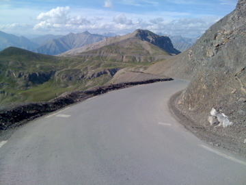
Steepness is the lesser problem on this climb – the length and the altitude are the problems. The pass itself is seldom talked about as the road continues up to Cime de Bonette. At the highest point there is a monument and a path up to the real Cime de Bonette. The pass is a little narrow opening in the mountain wall almost as if it had been cut out from the rock wall. Without that opening the pass might have been the same as the Col de la Moutière (2444m) far below the monument on the circle road.
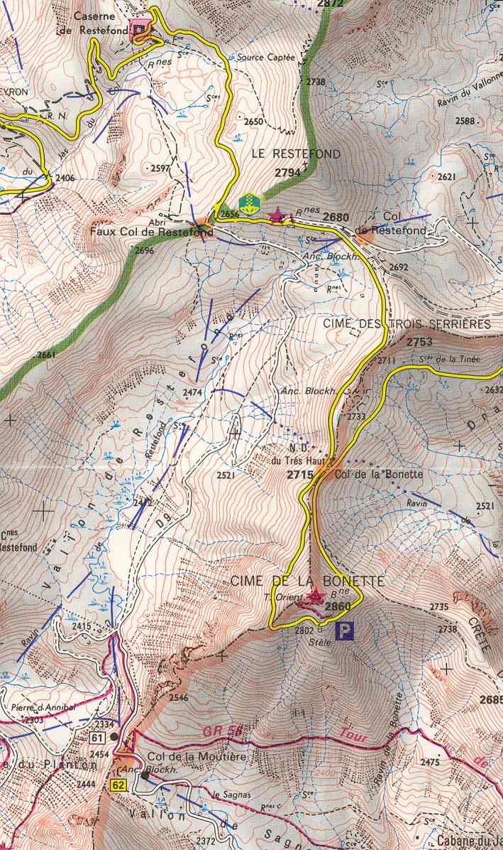
This pass is a classic. Fill up with water before the final climb begins as there is not much water to be found higher up on either side (there is one bar at Bousiéyas (1883m) on the south side that may be open). Before the new Bonette road was built, the pass road used to go over the Col de Restefond (2680m) instead. Here you can see an extract of the official IGN map of the area: Bonette IGN map at centcols.org. See also: Faux Col de Restefond (2649m) and Col des Granges Communes/Col du Raspaillon/Col de Vermillou (2513m).
[FR-04-2715, BIG 308]