Sign 2083m
625m - 9.2 km (Lanslevillard)
1670m - 30.3 km (Susa)
1784m - 37.8 km (Susa-Moncenisio)
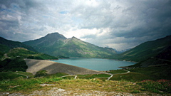
West of the pass in France the climb starts already down at Saint-Michel-de-Maurienne (715m) if coming up the Modane valley via Lanslebourg (1399m) or in Lanslevillard (1458m) if coming down from the Col de l’Iseran (2764m). It is a rather easy climb up many hairpins through woods. After the pass height there is a large area around the big lake/dam that is almost level.
It is a little up and down (adding ca. 110m to the climb from Italy) before the road goes down a myriad of bends on a perfect road to Susa (500m) in Italy (the most pleasant road to descend in the Alps with a road bike in my opinion). The climb from Susa is quite hard, but at least somewhat evenly steep all the time. You could climb up via the village of Moncenisio on a somewhat steep and narrow alternative road that eventually joins the main road before reaching the border to France.
[FR-73-2081, BIG 288]