Sign 2645m
1243m - 18 km (Valloire)
2294m - 38.5 km (Le Bochet via Col d’Albanne)
1438m - 36.3 km (Briançon)
1382m - 34.7 km (Briançon (north))
1925m - 46.9 km (Bourg-d’Oisans)
1814m - 36.2 km (Le Freney)
1598m - 33.3 km (Barrage du Chambon)
You can go all the way from Grenoble up to Col du Galibier without any descent, which makes it one of the longest climbs in the Alps with approximately 2400 height metres to climb. The real climb on the southwest side starts at Bourg-d’Oisans (717m) (soon after). You could also start later at Le Freney-d’Oisans (828m) or at Barrage du Chambon (1044m). The southeast climb starts in Briançon (1204m or 1260m), which is the highest town in the Alps.
The hardest side is the north side though. This climb starts in Saint-Michel-de-Maurienne (715m) and passes by Col du Télégraphe (1566m) where it is downhill, via Le Col (1535m), to Valloire (1399m). From Valloire it is fairly steep all the way up to the pass. It is however never steeper than 12%. See profile for the north side. You can also climb via Col d’Albanne (1653m) and Valloire to the pass, but this involves walking for half a kilometre or more on a stony path, but it is the hardest and longest climb from the north.
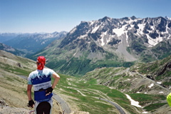
This pass is only rivalled in popularity by the Passo dello Stelvio/Stilfser Joch/Pass da Stielva (2758m) in Italy. No high mountain pass have gained such a prominent place in the history of the Tour de France as the Galibier. It is difficult to find a cyclist interested in mountain cycling who has not been here already. The popular cyclist event La Marmotte also let ordinary cyclists compete over this mountain pass (and others) each year. It is quite beautiful (around the higher areas) and quite hard as it is a long climb from any direction. Water can be found for example at Valloire on the north side and at Col du Lautaret (2057m) on the south side. There are much traffic down in the Maurienne valley and also until Col du Lautaret on the south side.
A little before the pass on the north side, you touches another pass – Collet du Plan Nicolas (2405m). You can make detours (cul-de-sac roads) on the approaches from the south. Outside Briançon at Chantemerle (1368m) you could climb the hard Col de Granon (2405m - 11.1 km) and just above La Grave there is a steep road up to Le Chazelet and Col des Portes (1834m - 4.4 km), with great views of La Meije (3983m), the most well-known mountain in the Massif des Écrins.
[FR-05-2642a, BIG 291]