739m - 15.5 km (Erlsbach); 1469m - 42.5 km (Huben); 1609m - 61.5 (Lienz)
This climb is a very nice one in fine weather. The Italian side climb starts in Sand in Bruneck/Brunico (834m), but more properly in Taufers/Campo Tures (868m). The road is often somewhat steep up to Rein in Taufers/Riva di Tures and soon thereafter the paved road ends by a parking. Here there is a flat section on a gravel road, but the road then climbs rather steeply again as it passes by the last farm house on the way up to the pass. The roads winds its ways to the pass, but is always possible to ride with a road bike in good weather.
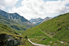
The Austrian side is less steep and there is only one switchback below the pass. One takes off the road to Staller Sattel/Passo Stalle (2052m) at Erlsbach (1549m) and then follows the asphalt roads that ends by a restaurant. The gravel road is longer on this side, but just as good (or possibly better). One could starts the climb already down at Huben (819m) on the road to Felbertauern (tunnel) (1632m) or indeed from Lienz (679m). Gravel road conditions may of course change![AT-OT-2288]