Today it was time getting slightly out of the area southwards, but not exactly via the most expedient route. Faced with three alternative roads: going back down Cortina; going up the Giau pass or going up the Falzarego pass, I have found another alternative. I went up in the direction of the Falzarego pass and just before the stretch of more level road finishes, a side road appears to the left (if you keep looking for it). I tried to make out whether that road was surfaced or not while going this way in the race the first day, but could not really tell then and thought it looked like an obscure gravel road into the woods. I tried to see the connecting road on the other side going down on the south side of the Giau pass, and saw a gravel road which did not look very good (but could not make out the exact quality).
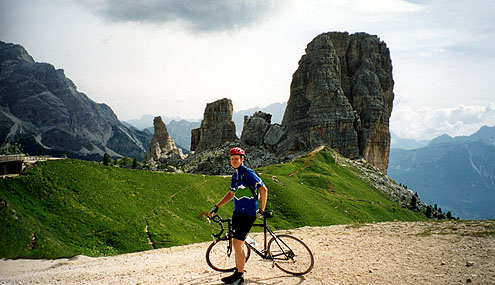
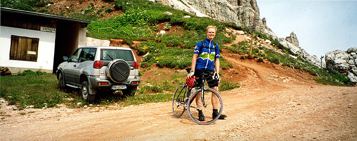
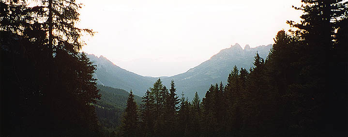
The little side road going off the Falzarego road goes up to the rifugio Cinque Torri (2137 m and thus higher than the Falzarego pass) and it is indeed surfaced all the way to the Cinque Torri, but it is one of the steepest roads in the Dolomites with a couple of stretches over and around 20%. It is also extremely narrow (a car passed me by on a 20% section and it was rather tricky). The photo from the right was taken after walking up a not cyclable gravel road from the rifugio. This is really a pass here, but I have not been able to find a name for it on any map, nor did I see a sign. I first thought I had already reached the Forcella Nuvolau at 2413 meters height, but soon realized it was further up (behind in the direction from where the photo was taken).
The road up to the Forcella Nuvolau was even less possible to cycle on (it is doubtful if you could get up here on a mountainbike). Jeeps and off-road motorcycles make it to the top. The couple of meters you see in the photo are cyclable, but that's about all before you reach the tarmac road up the south side of the Giau pass. You also see the path going off toward Forcella Averau behind me, but I was not really into exploring it, the views were quite good as it was from here! I guess it would be better trying the more tricky path toward the Nuvolau mountain if one wished to get even better views. The views were so impossible to capture in photos and the sun was not favourable, so I decided to let it stay as a memory only in my head. far in the right you can look down to the Pordoi pass and down to the left you can see the Passo di Fedáia and the Marmolada (highest dolomite mountain and I believe the only one with a glacier). There were a group of young kids who were a bit surprised to find me there with a road bike bicycle and it might be a crazy, but the walk is only 1 hour 45 minute in total between where you can cycle and the views were clearly worth it, I think.
I had hoped to be able to cycle some on the descent, but it was only possible for roughly 50 meters somewhere in the middle. Half of it would be cyclable on an mtb, I guess, but a downhill bike would be best here as it was rather steep at first. I think the first part were a ski slope.
I guess it was 11 a.m. when I reached the Giau pass road and headed down to Selva di Cadore and for some reason I decided to go the same way back over St. Lucia as I went in the race as I thought it was nicer than the road down in the valley, both leading to Caprile and the start of the climb up the Passo di Fedáia. However, at St. Lucia I got my first flat. Then someone thought the road in the valley was preferable there at St. Lucia, so I decided to go back and take that instead. It is ok, but mostly a fast way to get down to Caprile.
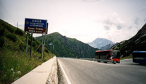
The road up on the east side of the Passo di Fedáia is usually regarded as very tough, but I could not really get very impressed as it was rather flat in comparison to the road up the Cinque Torri earlier in the day. It has been suggested to me that one could reach very high speeds if going down this side and there is a rather long straight stretch with gradients of around 14-15%, but I found the surface to be slightly bad and would not have wished to go down there at close to 100 km/h. There should be a smaller alternative road up part of the valley, but I failed to get off at the right place myself and took the ordinary way up.
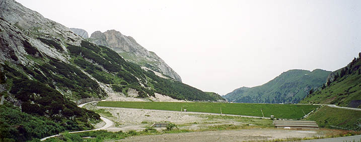
It is actually nicer in the beginning of the climb than later on and it is amazingly boring views at the top. However, the views improves along, and the further you get to the west edge of the dam up here. I went along the left side of the dam, which is slightly bad in a few places (one place in the beginning where the asphalt was so bad I had to go off the bicycle, but then could cycle on without a problem). Straight up on the left side one sees the Marmolada, but only near the end of this road on this side of the dam. I took a photo there, but the white-capped Marmolada was difficult to get to stay visible on the photo (I leave it out).
I asked about possibilities in getting down the other side continuing on the left side, but it was apparently only possible on foot paths (if at all). I went down on the somewhat busier west side. It is not very nice further down this road.
In Canazei I bought a new inner tube as I always want to have one good extra with me for quick replacement.
Now it was already over 15.30 p.m. and I had some serious thoughts about the next things on my original plan. I had two roughstuff passes coming up next and it seemed like it would not be possible to do both this day and if not this day, then it would not be a good idea doing them the next (since I needed to get on as I was already a bit behind schedule (partly because I had not originally planned the route for day two as I did it)). I just could not make up my mind about whether to go up the tricky gravel road to Malknecht Joch from Campitello di Fassa and waited until 16 p.m. to ask them at the tourist bureau (which opened again then) about the road up there. The girl there was actually of some help and I asked her which road would be easiest to cycle up on with a road bike – the Malknecht Joch/Pas de Duron (they call it Pas de Duron there) road or the Passo di Lusia road from Moena. She called the tourist office in Moena and asked them about the Passo di Lusia. They concluded that the Lusia road was probably a bit easier and that there had been a mountainbike event going up that road (anyway). They thought both were probably a bit too steep though, but the Lusia one is the less steep one (well, it is more evenly steep … ). But then she suggested I could just as well try the Duron road anyway (maybe because she worked there :-)). Anyway she gave a good advice of which way to approach the Duron road (one should go up behind the little church on a cobblestoned road, which is paved all the way up to the houses you see above the village and where it is rather level for a few kilometres of decent gravel road).
However, this only made for a good start on the road up to Pas de Duron. Soon there came sections so steep I just could not manage them. Above 20% and looser gravel. I had to walk the steep sections and cycle the bit in-between. Suddenly, I heard thunder in the sky and instantly knew this would not be a pass I would reach. I took a photo just before I turned around of the nice scenery opening up just as I was catching the first glimpses of the ridge and pass ahead. It was already so dark in the sky that the flash went off, so the photo looks pretty strange (like a montage) and not beautiful as it really looked there (I was obviously in the way … ). Just as I turned back it started to rain and I and many walkers hurried down the valley. I managed to get to the houses above Campitello before the worst rain came and took shelter for a while.
I met a little group of Swedish walkers coming down from the mountain there and talked a little. I then cycled slowly down on the wet and very busy road toward Moena. sometime before Moena it was back to full sunshine and dry roads again. So maybe I could try Passo di Lusia after all then, I thought.
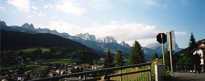
I took a photo in the direction of the Rosengarten ridge as I cycled up from Moena after having had dinner there. The only I took while cycling.
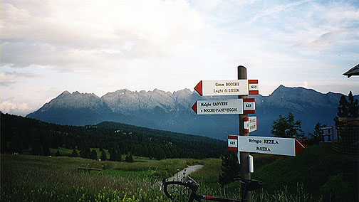
Soon after these serpentines up from Moena a little road goes off to the right and it is only surfaced the first few hundred meters and then becomes a somewhat ordinary gravel road. It is only that the gravel roads in the dolomites have harsher/sharper gravel than anywhere else I know of and it was soon rather steep and difficult all the time. It was a constant fight to stay on the bicycle and I was really getting tired. At the first rifugio on the way to the pass, I had already walked a little and after stopping there discussing the possibility of reaching the pass before dark and getting back again, I had to walk most of thee part as I was simply to tired to continue on the constant struggle involved in trying to cycle up here. The last part was a bit easier and better though and I decided to cycle again there. I walked together for quite some time with an older man and a little girl up there. The old man (of the mountain) was actually running the rifugio you see high up on the right hand when approaching the Lusia pass.
The Lusia pass has a long slightly sloping alm (farming area) on the other side and there are good views from the top in both directions. It is slightly boring just at the pass, but the views are nice. I lost the man and the girl on the way up there (they were slightly sceptical of the idea of going up there at this hour). I thought if worse comes to worst, then I could stay at one of the rifugios up here. I thought the old man and the girl had taken a shortcut over to the rifugio, but then met them again when descending. I had planned to try and get down another road toward a higher laying point on the road up to the Passo di San Pellegrino at Fango and asked the man about it. He described a forest path, writing with his walking stick in the sand, which was a good short-cut to that road, so I did not have to descend and then climb over hundred meters of height again. (Forstweg 236: get a walking map.) I took two photos along this path in the woods, the views were much nicer than the photos make them out. However, I did not understand I still should go up when I reached the gravel road and went down, ending up on the same road I had forced my way up on, only making the whole descent taking longer time. I was close to falling several times on the way down and should probably not have tried to cycle all the way, but I was determined to get down on the asphalt road again. I wished I had a photo of the man and the girl, but felt that it was to kill all the mythic aspects and that it was sort of disrespectful to everyone (you inclusive).
It was totally dark by the time I reached the main road and now I had a long road ahead up the Passo di San Pellegrino road. I got good use of my lights now anyway. I thought I should just continue until I found a good place to stay for the night. It turned out there was only one place that looked like a good choice above Fango (and not so far from the pass) – the Bucavene hotel, which was not good and not cheap, even though it looked that way. It was now 10 p.m. and I was not in the mood of trying to get over and down to Falcade on the other side of the Pellegrino pass. It is both difficult to get places to stay for the night after 10 and I would not see the pass in daylight and I also thought it was a bit longer than it was.
Day1 – Day 2 – Day 3 – Day 4 – Day 5 – Day 6 – Day 7 – Day 8 – Day 9 – Day 10 – Day 11 – Day 12 – Day 13 – Day 14 – Day 15 – Day 16