701m - 9.9 km (Premadio)
593m - 8.4 km (Valdidentro)
77m - 11.2 km (Arnoga)
There is one water tap early on – make use of it! For further information, see Passo di Val/Valle Alpisella/Pass d’Alpisella (2287m). You can possibly go over Passo di Valle Alpisella to get to Livigno (but you will likely have to walk for a while with a road bike).
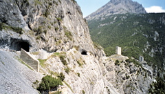
The Passo Torre di Fraele pass is mentioned on a Mair map, but also as La Bocchetta on the Swiss official maps. Both locate it near or at the top of a small road now only usable on the Cancano side at Alpe Scala (1973m), which I believe used to be the high point of the road to the Cancano lake, but now the high point and more obvious pass is located just after the Torri di Fraele just where the new asphalt ends, thus I am relocating the pass there as it is anyway the same pass for all practical concerns (and guess that it is also where people would believe the pass is now located). Actually one version of the first map has it located by the towers, but with the wrong height.
[IT-SO-1941]