Sign 1918m
1149m - 18.3 km (Cencenighe Agordino)
715m - 11.3 km (Moena north)
729m - 11 km (Moena Someda)
745m - 10.9 km (Moena centro)
755m - 11.7 km (Moena SS346)
759m - 11.6 km (Moena south)
[IT-TN-1947]
|
Height | Climbing height - length |
| 1919m Sign 1918m |
513m - 5.7 km (Falcade Alto) 1149m - 18.3 km (Cencenighe Agordino) 715m - 11.3 km (Moena north) 729m - 11 km (Moena Someda) 745m - 10.9 km (Moena centro) 755m - 11.7 km (Moena SS346) 759m - 11.6 km (Moena south) |
|
| Difficulty | Beauty | |
| East 3 (5); West 2 (5) | 2-3 (5) | |
| How to get there | From the east you start down in the Agordino valley at Cencenighe Agordino (770m) or just above Falcade at 1406m when coming down from Passo di Vallés/Passo Vàles (2033m). From Falcade/Falciade it is steep up to the pass (you could gain quite high speed down this side). From the west the climb starts in Moena (1164m) (and either one goes up the small Someda road) or follows the main road all the time (see the map for some variants at the start). The climb from the west is rather easy. | |
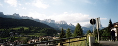
| Other comments | This is a somewhat easy pass and surprisingly uninteresting (the beginning of each aproach are the nicest parts). There are lots of hotels at the pass height as it is a ski resort. Photo is from just above Moena (taken while riding up there on the main SS346 road). Passo del Lusia/Pas de Lujia (2053m) is a pass above Moena that could reached by taking off the road to the right on a gravel road that looks like it might be possible to use with a road bike, but it is rather bad gravel and then often around 15% and I would say it might be the hardest road that could possibly be climbed on a road bike (I had to walk parts of it, but I am sure someone can do it). [IT-TN-1947] |
|
| Map |
||