591m - 12.3 km (Briançon north)
462m - 7.1 km (Clarée valley)
509m - 9.6 km (Cesana Torinese)
777m - 19.5 km (Oulx)
1471m - 43 km (Susa)
[FR-05-1850]
|
Height | Climbing height - length |
| 1851m | 647m - 12.8 km (Briançon) 591m - 12.3 km (Briançon north) 462m - 7.1 km (Clarée valley) 509m - 9.6 km (Cesana Torinese) 777m - 19.5 km (Oulx) 1471m - 43 km (Susa) |
|
| Difficulty | Beauty | |
| 2 (5) | 2-3 (5) | |
| How to get there | The pass is just inside the French border on an easy crossing between France and Italy. It is the easiest crossing of the Alps in this part of the Alps. (The next one would be the Brennerpass.) You start the climb from France in the highest town in the Alps, Briançon (1204m or 1260m), or further up on the road at the second of two alternative roads into Vallée de la Clarée (1389m). The climbing really starts only after this last point and it is brief. The Italian side is somewhat similar (new tunnel built in 2006) and the climb here starts in Cesana Torinese (1342m) if coming down from Colle del Sestriere (2036m) or possibly further down in Oulx (1074m) if making a loop ride over the Col de l’Échelle/Colle della Scala (1762m) or all the way down in Susa (500m). | |
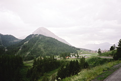
| Other comments | There are tourist villages on both the French (Montegenèvre) and the Italian (Clavière) side of the pass. Before going into Italy you can turn off on a small asphalt road (in the direction of Italy) to nearby Le Collet (1856m) (no sign and no real pass but recognised by Club des Cent Cols, located just above a parking place). That road ends at some hotels. (Photo taken at Le Collet in the direction of Col de Montgenèvre.) [FR-05-1850] |
|
| Map |
||