1217m - 25.1 km (Pont de Thézières)
1363m - 29 km (Marignier)
1350m - 27.62 km (Cluses)
[FR-74-1843]
|
Height | Climbing height - length |
| 1844m | 1349m - 21 km (Balme) 1217m - 25.1 km (Pont de Thézières) 1363m - 29 km (Marignier) 1350m - 27.62 km (Cluses) |
|
| Difficulty | Beauty | |
| 4 (5) | 3-4 (5) | |
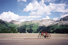
| How to get there | The climb starts in Balme (495m) just east of Cluses (toward Sallanches). Alternative climbs starts north from Taninges at Pont de Thézières (627m) or south-west from Marignier (481m) or Cluses (494m). All these three alternative roads goes via Châtillon-sur-Cluses/Col de Chatillon (741m) and continues via St. Sigismond (950m) to meet the other road at Arâches-la-Frasse (952m). The road leads to the Flaine ski resort, just below on the other side of the pass. Here the road ends and only paths and mule tracks continue elsewhere. It is a long and hard climb from Balme, esp. if it is hot. | |
| Other comments | The main village on the road is Carroz (1109m), which is a few kilometres after Arâches-la-Frasse. At Carroz there is a grocery store and bars/cafés. [FR-74-1843] |
|
| Map |
||