Sign 1789m
1047m - 19.6 km (St. Lorenzen/S. Lorenzo di Sebato via high road)
751m - 12 km (Zwischenwasser/Longega)
793m - 12.5 km (Niederolang/Valdaora di Sotto)
969m - 21.4 km (Bruneck/Brunico)
759m - 11.7 km (Mitterolang/Valdaora di Mezzo)
756m - 12.7 km (Oberolang/Valdaora di Sopra)
You can start all the way down northwest at St. Lorenzen/S. Lorenzo di Sebato (806m). The road up to Longega/Zwischenwasser (1012m) is a busy road with many tunnels (there has been a lot of roadwork going on for years on this stretch and still were in 2006, but they seem to have completed it in 2008). From Longega/Zwischenwasser you take the less busy road to the right up to Al Plan/St. Vigil/S. Vigilio (1179m) where the real climb begins (to the right again). An alternative high road above the main road up the Val Badia/Gadertal would be recommended and it is also a bit shorter (see map below).
From northeast side the climb starts in Mitterolang/Valdaora di Mezzo (1004m) if coming from Staller Sattel/Passo Stalle (2052m). If coming from Toblacher Sattel/Sella di Dobbiaco (1221m), the climb is best started at Oberolang/Valdaora di Sopra (1059m) with some ups and downs before joing the main road up the pass (one could also use the Sallastrasse to/from Welsberg). If coming from Bruneck/Brunico (834m), one turns off to Niederolang/Valdaora di Sotto (970m). The road is very good, but the last 5 km on both sides are quite steep.
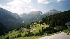
You are on the border to the Dolomites here and the mountains looks more like in Austria. It is still quite beautiful here. The pass itself was a construction site when I visited the pass in 2003, but now the work on the reservoir at the top is finished and it looks nice now at the pass height too. I am not sure which of all names is most used by the locals, but the first two names appear on the sign there (but the locals does not always seem to be able to decide what the sign should say). I just list all official names I have found.
Of much interest lately, since it has been used in the Giro d’Italia is the contuing gravel road up to the ski station at Kronplatz/Plan de Corones (2274m), which has always been known for being a very steep climb. I did not have time upon my third visit there to climb this road, but it starts with a concrete section at the turn-off (1735m). The steepest part is toward the end of this 5.3 km road.
If one has a mountainbike one could start the climb in Al Plan/St. Vigil/S. Vigilio, if coming over the interesting and beautiful roads from Limojoch (with bad gravel and over 30% steepness at places) or Fodara Vedla (with its +30% concrete serpentines).
[IT-BZ-1759, BIG 709]