[IT-CN-1723]
|
Height | Climbing height - length |
| 1712m | 1098m - 15.7 km (near Melle) |
|
| Difficulty | Beauty | |
| 3-4 (5) | 3-4 (5) | |
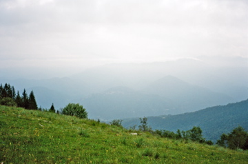
| How to get there | This climb starts on an asphalt road (SP 109) from before Melle (639m) on the way up in Valle Varaita, Piemonte. This road goes up to Santuario di Valmala (1379m) and it is a very good and nice lonely road. After the santuario the road goes down a little and starts to rise again as it comes to Passo Pian Pietro (1354m). From here the road is very poor even though asphalted as it is very thinly asphalted (it looks good, but it is like cycling on a washing tray). This is where you join the old military ridge road that goes all the way to Colle di Sampéyre/Col d’Sampeyre (2284m) and beyond. It is called Strada dei Canoni and is a very popular road among mountain bike cyclists. The road is never very steep, but it is a hard climb nonetheless. You also pass by Colle di Palmascura (1650m) on the way to the end of the asphalt at the Ciabra pass. The gravel road is too harsh for a road bike from Ciabra onwards. The Ciabra pass sign and actual pass is 100m after the asphalt ends. | |
| Other comments | There are nice views from the top! There are no other fully asphalted approaches. You come close to Colle di Valmala (1541m), but this pass is 300m away on a bad and steep gravel road. At Passo Pian Pietro one could turn down a gravel road to Lemma (1013m) (ordinary blue road sign here), but I cannot recommend it if you have a road bike as it is hard going down to Lemma on the poor gravel, though I did it myself and from Lemma down to Colletto di Rossana (617m) it is a very nice asphalt road. (There have been plans on asphalting the whole Strada dei Canoni, which would have been nice for us road bicyclists, but this will apparently not happen now.) [IT-CN-1723] |
|
| Map |
||