845m - 20.5 km (Pont de la Guingerre)
726m - 11.6 km (Noyer/St. Bonnett)
[FR-05-1696]
|
Height | Climbing height - length |
| 1696m | 959m - 12.6 km (Gap) 845m - 20.5 km (Pont de la Guingerre) 726m - 11.6 km (Noyer/St. Bonnett) |
|
| Difficulty | Beauty | |
| 4 (5) Gap; 3 (5) | 3 (5) | |
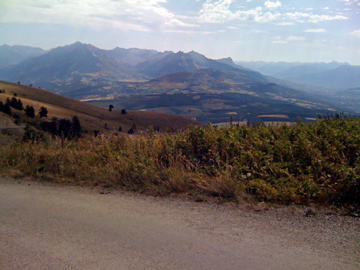
| How to get there | This pass is a little known one that can be reached by a small forestry road leaving the Route Napoleon between Gap and Grenoble just before Col Bayard (1248m) on the north side. The surface is a bit rough but improves a bit higher up. It is steep (ca. 10% on average) and it could be very warm here and there are only a few trees at the start along the road. No water along the road. The climb that includes the Bayard climb would start in either Gap (740m) or Pont de la Guingerre (851m), or at the St. Bonnet/Col du Noyer roundabout (970m) if coming from Col du Noyer (1664m). The climb from Gap is hardest. | |
| Other comments | At the top a gravel road continues to further passes: 800m to Col du Milieu (1738m) and 2.3 km to Col de Chabanottes/Challanotte (1663m). This road is only for authorised cars and mountain bikes are not allowed to access the road. But it is possible to use with a road bike and I went easily up to the first of the passes here, but did not want to descend the gravel road further ahead. The road is somewhat popular for the nice views and access to the abandoned village of Chaudun (beginning of the 20th century). You should try and go the more straight road up from Gap that rejoins the main road later on. [FR-05-1696] |
|
| Map |
||