595m - 6.1 km (659m - 6.7 km) (Kappelboden)
[CH-BE-1604]
|
Height | Climbing height - length |
| 1616m (1680m) | 515m - 5.2 km (579m - 5.8 km) (Reidigenstrasse/Büel) 595m - 6.1 km (659m - 6.7 km) (Kappelboden) |
|
| Difficulty | Beauty | |
| 3-4 (5) | 3-4 (5) | |
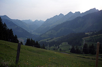
| How to get there | This is a short climb from Kappelboden (1021m) just above Jaun, where the real climb up to Jaunpass/Col de Bellegarde/Bruchbergpass (1508m) starts. Just a bit up on the road to Jaunpass there is a road going off to the left called Reidigenstrasse (1101m). Follow this loevely narrow road up the mountain until you reach a crossroads with two alternative asphalt roads, both of which sort of brings you to the pass, but the one going to Fluehebärg (a poorly home made sign) is more direct. Eventually you see a gravel road with a fence traversing the pass. That road looks fine for a road bike, but should end shortly down the other side from where there is only a path down. Instead follow the asphalt road every steeply up to the end (Fluehebärg) 1680m and preferably a bit longer to get a glimpse of the other side, but it is the same thing here that the gravel road going down here soon ends (it is also a slightly different crossing). The climb is quite steep but never very steep. | |
| Other comments | The views from the higher points around the pass are quite good and it is such a nice and little used road that I could recmmend it to anyone (the highest asphalted point is at the end of the road you turned off at 1693m). One only wished that it would be possible to get down the other side. I had no cars on the way up or down (and no one else either). From Jaun (1015m) you could also climb the Euschelspass/Neuschelspass (1580m) (walking pass at 1567m), which is asphalted or concrete pavement all the way, but be warned about the last steep ramp with up to 25%! If you do not want to take the Jaunpass out of the valley, you should consider Mittelberg/Grubenbergpass (1634m) which is a nice alternative, even if Jaunpass is nice too. [CH-BE-1604] |
|
| Map |
||