812m - 13.7 km (1282m - 19.5 km - Joch) (Passugg)
494m - 14.7 km (Alvaneu Dorf)
611m - 16.7 km (Alvaneu Bad)
702m - 14.1 km (Tiefencastel)
892m - 18.9 km (Sils)
From the north this climb starts at the centre of the capital of Graubünden in Chur/Cuira/Coira (595m). It is a bit challenging on this somewhat steep road and there is also a lot of traffic on this road. If you have been up to Arosa and Sattel (Mittler Hütte/Arosa) (2018m) then you may had went via Molinis to Tschiertschen and then the climb starts at Passugg (738m) (or if you came down from Farur (1939m)).
The north side climb could be made much more interesting and challenging, by taking off in Parpan to Joch (Churer Joch) (2020m), where the last part is on gravel road, but it is quite possible to climb there on a road bike!
From the south side there are several possibilities. If you com from the Davos area the climb starts high up just below Alvaneu Dorf (1056m) from where you go through a wooden covered bridge which is fairly uncommon on decently big through roads now like this.
If you come down the lovely Albulapass/Pass d’Alvra (2312m) the climb starts in Alvaneu Bad (939m). If you come down from Julierpass/Pass dal Güglia/Passo del Giulia (2284m) the climb starts Tiefencastel/Casti (848m) and is the straight way north from Julier.
Finally if you come from the Thusis area, the climb starts in Sils im Domleschg (683m) and here you do well to take the more direct road up from Punt da Solas (846m) via Zorten to the pass, a variant I have not tried myself yet, and which should be close to as hard as the climb from the north.
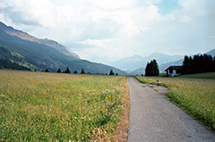
The road over Lenzerheide is practical, but surely not the nicest road given the traffic, but combined with an extended climb to Churer Joch (2020m) or perhaps up to Alp Lavoz (1954m), the climb will be much more nice and memorable! Photo here is on the way back down toward the Lenzerheide pass from Joch.
See also: Alp da Stierva (2146m), Obermutten (1864m), Flüelapass/Pass dal Flüela (2384m) and Wolfgangpass (1632m).
[CH-GR-1546b, BIG 592]