 Golet du Taisson Golet du Taisson |
 |
Height |
Climbing height - length |
| 1492m |
1008m - 20.3 km (Cusy)
1035m - 17.8 km (Bassa)
1074m - 17.6 km (Bassa (La Bottaz))
1104m - 17.5 km (Lachat)
1133m - 17.7 km (La Verdasse)
1195m - 18.5 km (Grésy-sur-Aix (Moulin Collet))
1205m - 18.9 km (Grésy-sur-Aix)
1253m - 20.1 km (Aix-les-Bains)
1220m - 21.1 km (St-Alban-Leysse)
1009m - 18.4 km (Thoiry)
966m - 21.9 km (Le Pont) |
| Difficulty |
Beauty |
| 3 (5) |
3-4 (5) |
| How to get there |
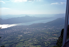
This pass is located on a detour circular road near the top of Mont Revard (1536m) You go from from 1495m to 1490m at the pass. and then climb back up to the main road. The Golet de la Pierre (Mont Revard) (1510m) is on another little circular road just above this. See that pass for more information on the climbs here. |
| Other comments |
Better climb up to Mont Revard first and visit these detour roads on the way down if you care to. Photo from Mont Revard.
[FR-73-1487] |
Map
|
|