Sign 1470m
824m - 12.1 km (Les Scaffarels)
[FR-04-1475]
|
Height | Climbing height - length |
| 1473m Sign 1470m |
784m - 9.9 km (Annot) 824m - 12.1 km (Les Scaffarels) |
|
| Difficulty | Beauty | |
| 3-4 (5) | 2-3 (5) | |
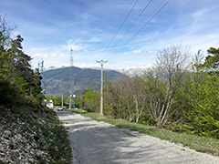
| How to get there | This is a hard climb from Annot (689m) on the way up to (or down from) La Colle Saint-Michel (1431m). It is quite nice in the valley of Annot and up to Colle Saint-Michel, but not so nice up here as it is mostly wooded. There are a few good views higher up. One could continue a bit on the gravel roads on the other side for a bit better views in the west direction, but the best views are near the top to the east. Very steep at first, but mostly easier afterwards. Coming from the Var valley one starts at Les Scaffarels (N202) (649m). | |
| Other comments | Annot has cafés and a pastry shop and more. I am not sure how easy it would be to get down on the gravel road going south at the pass, which should meet another pass lower down and turn to asphalt there or further down. I went a few hundred metres on the very exposed gravel road going north instead before returning back. [FR-04-1475] |
|
| Map |
||