Signs 2744m, 2748m
2144m - 45.5 km (Brossasco)
1428m - 25.2 km (Château-Queyras)
1784m - 41.7 km (Guillestre)
1925m - 45.5 km (Guillestre N94)
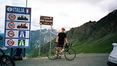
From Italy, if you come down from Colle di Sampeyre (2284m), you will go up the valley via Sampeyre (958m). At Casteldelfino (1296m) it gets a bit steeper, but it is first at Chianale (1797m) that it becomes really steep. There is at least a kilometre with around 14% on average that makes this side very hard. It is seldom that the really high pass roads have so steep sections. The road climbs all the way from Brossasco (600m) (and even before that) up the long Valle Varaita.
The road up from Château-Queyras (1353m) in France, where you start if coming down from Col d’Izoard (2361m), is easier although a bit unregular. One could also start further down at Guillestre (1037m) if coming down from Col de Vars (2109m) or below at the N94 (896m) for a really long climb. The surface is good on the Italian side, and fine on the French side too. At altimetrias.com is a profile of the pass on the Italian side and the French side.
This is one of the least talked about of the really high passes in France and Italy. It is seldom used in Tour de France and Giro d’Italia, but it was used in TdF 2008. This pass is superb to use to make a route into Italy from France in order to visit the wonderful Valcavera/Morti and Sampeyre passes, that are among the most beautiful road passes in the Alps. There are water at Casteldelfino in Italy and on some other places on both sides of the pass.
On the French side you could also make a detour up to St. Véran (2065m at the highest asphalted point up a steep ramp) and possibly also the the gravel road to Chapelle de Clausis (2388m). The climb from Château-Queyras to Sommet Bucher (2225m) cannot really be recommended even if you have great views at the very end as there is a harsh gravel road section and more (but easier higher up). From Pont de Piere/Maison du Roi (1057m) you could also climb above 2000m height above Ceillac to Le Bois Noir/Le Rioufenc/Vallée de Cristillan (2012m) and this is a quite nice road.
The road to Belvédère du Mont Viso (2150m) used to be fine with a road bike and mostly paved, but it has turned into a quite bad road that I doubt is worth to try with a road bike these days, even if I noticed a YouTube video showing three guys making their way up and down there on road bikes (I would have gone down slower ;-)). Also in the map you can notice the climb up above Risoul on a gravel road to Col de Saluces (2444m), which is great if it remains as good as when I was there in 2004 (but not so good down the other side of the Valbelle pass).
[FR-05-2744]