522m - 6.3 km (Sacklhütte); 1449m - 25.2 km (Unter-Winkl); 1496m - 27 km (Ebene-Reichenau)
[AT-KÄ-2049]
|
Height | Climbing height - length |
| 2049m | 577m - 8.2 km (Innerkrems);1097m - 17.8 km (Kremsbrücke) 522m - 6.3 km (Sacklhütte); 1449m - 25.2 km (Unter-Winkl); 1496m - 27 km (Ebene-Reichenau) |
|
| Difficulty | Beauty | |
| West 3 (5); East 2 (5) (Sacklhütte) | 4 (5) | |
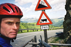
| How to get there | A good road (Nockalmstrasse) goes from nice little village of Ebene-Reichenau (1057m) to the Schiestelscharte/Glockenhütte (2029m) before descending to Sacklhütte (1527m). If you come down the steep Turracherhöhe (1794m) you start the climb at Unter-Winkl (1104m). From here the road rises nicely in serpentines to the highest point of the road, which is this pass. From the west side the climb starts properly at Innerkrems (1472m), but one could start the climb from down at Kremsbrücke (952m). It is not too difficult with a maximum steepness around 12%. | |
| Other comments | The pass road is called the Nockalmstrasse and is a touristic road through a national park. It is quite nice in this area, especially up at Schiestelscharte/Glockenhütte where you pass a nice little lake and in the area between the two high points of the road. There are bars at both heights and at Sacklhütte in between. (Eisentalhöhe is really the mountaintop which you come near at the highest point, but this is also a pass – the walking pass below is at around 1875m height.) The photo is taken from the Schiestelscharte/Glockenhütte in the direction of this pass. [AT-KÄ-2049] |
|
| Map |
||