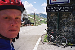
Sign 2188m
1375m - 30.2 km (Bourg-St. Maurice)
1295m - 23.8 km (Séez via Montevalezan)
1378m - 25.7 km (Séez fr. L’Isère via Montevalezan)
1295m - 27.4 km (Séez)
1378m - 29.3 km (Séez fr. L’Isère)
1127m - 20.3 km (Ste-Foy-Tarentaise)
1773m - 29.8 km (Morgex via Colle San Carlo)
1151m - 22.5 km (Pré-Saint-Didier)
There is a nicely hairpinned road from the west to this classic pass starting in Bourg-St. Maurice (813m). If you are coming down from Col de l’Iseran (2764m) you can start in Séez (894m or 810m) or better from Ste-Foy-Tarentaise (1062m). The climb via Montvalezan is giving the pass a bit steepness on the south side, which is otherwise not very steep, but long.
The regular climb from the Aosta valley starts in Pré-Saint-Didier (1038m) and is long, but not so very steep. For the absolutely hardest climb one should start in Morgex (922m) and take a short-cut up via Colle San Carlo/Col Saint-Charles (1953m), which happens to be one of the most consistently steep pass roads in the Alps with around 10% on average for 1031 height metres, and after a 6 km descent, continue up from La Thuile (1447m) to the pass.
It is very nice higher up on this pass on both sides. The pass itself is a very popular place for tourists and locals alike and one of the oldest used high passes in the Alps, I believe. It was regularly used already in the 1800th century and that is probably why the gradient of the climb is never very high. There is a Napoléon monument at the top and other historical buildings. Just at the pass the road has been changed to make a small detour around the pass point since 2012 (I think).
There should be water (and shops) at La Rosière on the southwest side and at La Thuile on the northeast. There is a good hotel in Morgex by the main road (old comment).
There are many paths and tracks going from the top to the mountains and passes nearby: Col de la Traversette (2383m) (where one has to walk up a steep ramp); Touriasse (2404m) 2.1 km on the way to Col de la Fourclaz (2482m) is a decent gravel road from top of the pass on the Italian side with great views of the Mont Blanc, but the last ramp up to the Fourclaz is too bad for use with a road bike – I tried walking down the other side of Touriasse thinking I was up at the Fourclaz pass, but that was not a good idea – better then to walk up the Fourclaz pass and walk/cycle down the other side there. La Suche (2233m) is the highest asphalted point (last bit from 2208m has lost some asphalt) in the area and is located on the Italian side on the other way up to the Fourclaz pass from 1966m (and 3.6 km) on the N26.
[FR-73-2188, BIG 285]