714m - 9.7 km (Bivio Dogana Vecchia)
1534m - 33.67 km (Santa Catarina)
935m - 13.3 km (Schluderbach/Carbonin)
1164m - 26.4 km (Toblach/Dobbiaco)
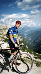
The road to Rifugio Auronzo and the Tre Cime di Lavaredo/Drei Zinnen is one of the most touristy roads in the Dolomites, because of the spectacular mountains and also because of the the many good walking paths that takes you to places and remnants of where the first World War was partly fought (also found on other roads in this area). The Tre Cime road is a toll road, but cyclists are not charged. Behind the Rifugio Auronzo, just to where the tarmac ends, a difficult footpath could take one down the valley on the other side or one could take an easier one going down a bit ahead from the gravel road.
The unpaved continuation of the road by the rifugio takes you to Rifugio Lavaredo (1.7 km), where it is no longer possible to continue cycling on a road bike. But you could walk up the last 930m to the Forcella Lavaredo/Paternsattel (2454m). This is recommended for the fantastic views from up there. No wonder this is the most popular place to visit in the Dolomites! See the unpaved section for more on this pass. There is a good water tap at Misurina (on the east side of the road). See also: Forcella Àuta/Alta (1984m).
[IT-BL-2288, BIG 719]