1515m - 24.33 km - 6.2% (Franz-Josefs-Haus fr. Döllach via Apriach)
1649m - 38.44 km - 4.3% (Franz-Josefs-Haus via Heilgenblut)
1382m - 19.50 km - 7.1% (Franz-Josefs-Haus fr. Pockhorn/Rojach)
1629m - 36.75 km - 4.4% (Franz-Josefs-Höhe via Apriach)
1465m - 24.50 km - 6.0% (Franz-Josefs-Höhe fr. Döllach via Apriach)
1599m - 38.60 km - 4.1% (Franz-Josefs-Höhe via Heilgenblut)
1332m - 19.67 km - 6.8% (Franz-Josefs-Höhe fr. Pockhorn/Rojach)
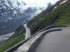
The side-road of the Großglockner road to Franz-Josefs-Höhe is almost as popular as the main road over Hochtor (2504m). This is not much of a climb if coming from the north where the climb starts at Guttal (1858m), which is also where you turn off the main road coming from the south. The approach from the south starts at Winklern (934m to 882m). The real climbing on the main road only starts at Pockhorn/Rojach (1107m), from where it is somewhat steep. It passes by the idyllic Heiligenblut (1291m) village.
Instead of taking the main road, the road via Apriach from Großkirchheim/Döllach (1006m) is nicer and actually shorter. There is a short descent to Guttal from Kasereck (1910m). After passing through the gallery and coming around the last corner one could alternatively go up a spectacular narrow serpentine road to the Franz-Josefs-Haus 2419m. If taking this road forbidden to regular traffic, make sure not to be a trouble to walkers who could be plentiful here (I was lucky myself though).