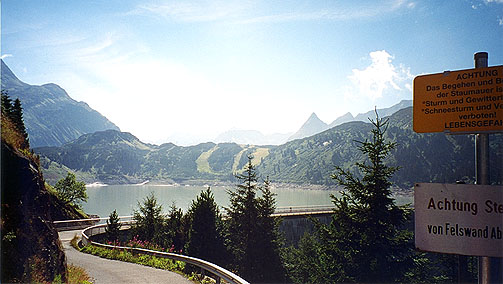
It was wonderful weather in the morning and I was happy I could visit the passes around there now. First I went up the first of two approaches (both tarmacced roads, but the first is very narrow and much steeper, but also nicer) to Zeinisjoch (1842m). This smaller road joins the wider toll road (no toll for cyclists). Make sure to continue on the road until you come upon the view in my first photo here. There are nice views in other directions too up here. I wished I had taken time to explore the gravel road toward the Verbellner Winterjöchl one see goes off to the right up the mountains (not visible in this photo). I had also first thought to continue on this road and the gravel one going down on the other side of the Bielerhöhe, but for some reason I decided to stay on tarmac and went back the wider road toward the Bielerhöhe road (and thus saved me one of the small stretches of some steepness on the main road).
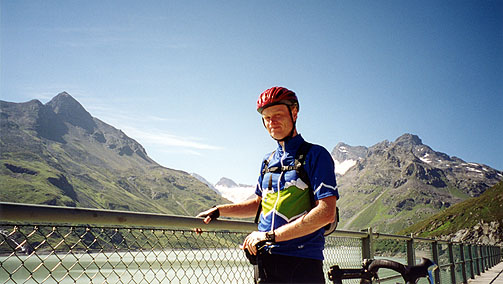
The road up to Bielerhöhe (2037m) is very easy on the east side. A French lady took the photo of me up there. It was very nice up there in the splendid weather and I was very happy I did not try to get up there the day before in the clouds and twilight.
I cycled back down through Galtür and continued down to Ischgl, where I turned off and went through the little village with all the hotels and turning right at the end I came upon a grocery and stopped to buy some extra supply and to get ready for the next climb and to ask the way (which was lucky I did, because I had thought should go straight there, but I should go up among the houses to the right again. The road up to Idalpe and Viderjoch is one of the toughest roads in the alps. It begins with a long stretch with gradients over 20% and never below something like 18%. Then you come to a water tap (very convenient) by a ski lift station. Here the road goes almost totally flat for a kilometre or so, before the final climb begins, which is like 5 km to Idalpe of fine tarmacced hairpins with average gradients again around 20% and up to 24%. Some mountain bikers had to walk and I passed by several on the climb up there. I saw no other road bike cyclists there. I met a downhiller on my way up to Idalpe – go figure! Then you come to the Idalpe ski station and there you should take the road climbing up which become a gravel road after passing the station to the left. Continue on this road another couple of hundred of meters and keep to the road that is never signed, but which leads to the Viderjoch (you see where it goes all the time). This road is indeed a very fine gravel road almost all the time, but there are a few short ramps with gradients of up to 30%, which is very likely to make you walk up them (but it really adds up to only about 50 meters of walking, if you are strong). The last stretch up to the Viderjoch is like 16% and is just about what one could manage to do with 39/27 at this altitude of around 2700 meters. When I reached the top I was more heavily breathing than ever before (including indoor cycle training).
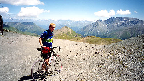
I talked a little with a French woman at Idalpe as she recognized my Club des Cent Cols jersey. Her husband is a member of the club also, but he was out there collecting cols (she was the only one I met on the trip who knew about my jersey). The views are very nice up at Viderjoch (2737m) and you can get up to the Greitspitze (2871m) rather easily and get even better views according to the Dutch couple who took the photo of me at the Viderjoch. I thought it was nice enough here, so I decided not to drag myself and the bicycle up there. Instead I continued straight ahead where I stand with my bicycle, but you do not see any kind of road in front of me, but there is! It is just that it starts out with and average gradient of near 45% ;-). It was dangerous even to walk down there as you can understand (there was an alternative path). Apart from that and perhaps two more ramps like the first with gradients over 40%, it was indeed a cyclable gravel road down there to Compatsch (1715m) in the Samnaun valley. With a downhill bike you could probably do the ramps as well.
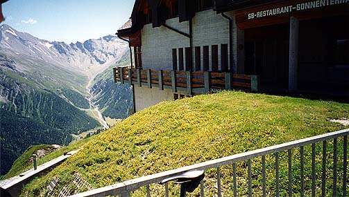
After a while and just as you see the Schihaus Alp Trida (2263m) you should take the road going right up to the Tridersattel/Alp Trida Sattel (2497m) – it is only 1-2 km on a cyclable (R1) road that is not very steep (from 2423m). At the Tridersattel there is another ski station and restaurant and you have again a very nice view down the direction I took the photo here. Then cycle all the way down carefully to Compatsch (1715m). The gravel road below Schihaus Alp Trida is often at around 20%, so it is just about cyclable with a road bike. I saw many people out doing farm work down there and it was perfect weather. A nice tarmac road starts 1-2 km before Compatsch. I had lunch at a grocery in Compatsch and got some very nice sandwiches with some local cheese on and had a free local yoghurt.
The small road with tunnels that keeps you in Switzerland all the time is a bit dangerous, with many cars and rather poor asphalt patchwork. The views are often very nice and is of the same area as the nice stretch below Nauders down on the road to Landeck. Before you reach Martina (1035m) in the lower Engadin valley the roads improves considerably. There are almost not one house on the way down there and the road itself hardly is place for as it clings rather desperately to the side of a steep mountain. At Martina I spent my last Swiss coins as I were about to leave Switzerland for this summer. Then I went over the bridge into Austria and climbed the serpentines up to Norberthöhe (1406m) which is just above Nauders. Then I joined the road up to the Reschenpass and passed into Italia again once more.
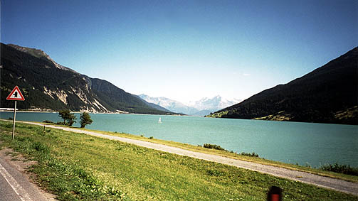
I was a bit boring and took the main road down the valley again. I took a photo of the Reschensee again. The huge serpentines (or main road with big bends) I feared I would have to pedal down as I did not think it was steep enough to simply roll down there when I went up, but it was just enough steep to get at a speed of above 60 km/h all the way and I could fantastically keep that speed in the bends as well, so it was more fun than I expected!
When I came close to Prato (where the famous road up to the Stelvio pass goes), I cycled over there and had something to eat (that damned grocery shop in Prato also was irritating to me already in 2000 – unfriendly people working there and hopeless to walk around inside with too many people and it is badly planned). The main reason I cycled into Prato was to get some postcards of the Stelvio pass to send home. I took a nicer alternative road out of Prato, via Tschengls (which involved a little climb up to that village, since I was unsure about the possible alternatives without signs through the plantations). On my way down to the main road at Lasa I nearly went straight into a reckless driver of a sports car when I just went through some heavy water sprinkling over the road from a water pipe and could not see him clearly. Thankfully it went well.
I then hurriedly continued down the Val Venosta, which was longer than I had remembered it from 2000. There are many interesting cul-de-sacs in the Venosta valley that I should perhaps explore another time. It was really high time for dinner when I reached Merano (302m) (I think I went off the big road all too late, but came in to the city centre rather directly). They have built a special road not allowed for cyclist from Naturns just to before you reach Merano and you have to go on some very car free roads (thankfully) down instead, but they are not very well signed and but you just go as straight as possible and you well get down right. You have to go over some cobblestones at one place and cross several bridges and the roads are very small.
Since I did not see any perfect place to stop for dinner during the ride through Merano, I decided to just keep going up in the direction of Hafling. It is indeed a very long climb to Hafling (1290m) which is rather relentless (average gradient may be 8% and it is close to a 1000 meter climb). I passed by early on a funny looking vehicle that an old man were driving along the road. It had a big water tank and some way to get the water to sprinkle out over the plantations. It looked like a ”steam car”.
I was fighting against the falling twilight and my tiredness. I arrived at Hafling just when it was about to get really dark. After a 2-3 attempts I found a very good place to stay for the night. (Turn right and right and go straight onto a gravel road (only 100 meter) and it was one of the houses there (with a dog).) Very good price and very fine building and breakfast and service! (20 euro and the best deal during this trip.) I managed to get some huge sandwiches at a restaurant, since it was too late for hot food. But that was fine with a few good beers also and the people there were really nice – it was also a hotel (more expensive looking, right and left off the main road). Talked a little about the trip for the day with people and went back to wash my clothes and go to bed. I picked up a book about Hafling/Avelengo to read as I went to bed and it was a bit interesting. The name Avelengo for Hafling was a name given to the village by the Fascists and hence not very popular (I guess this was the case with several other Italian named places up in the southern Tyrol as well). The village had a long history.
This is the day of my tour that I am most proud of and one that I greatly enjoyed.
Day1 – Day 2 – Day 3 – Day 4 – Day 5 – Day 6 – Day 7 – Day 8 – Day 9 – Day 10 – Day 11 – Day 12 – Day 13 – Day 14 – Day 15 – Day 16